Introduction – why “square kilometres” matter
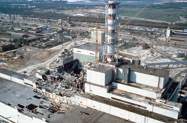
The Chernobyl disaster created a 30 km-radius Exclusion Zone whose core area is now legally restricted for the foreseeable future. Ukraine’s State Agency for Exclusion-Zone Management lists the zone at about 2,634 km² (1,017 mi²), later enlarged to roughly 4,143 km² (1,600 mi²) to encompass additional fallout hot-spots. WikipediaEncyclopedia Britannica
For context, 2,600 km² is:
-
a little larger than the U.S. state of Rhode Island’s land mass (2,678 km²), and
-
almost exactly the surface area of Lake Tahoe (497 km²) multiplied by five.
Quick conversion snapshot
| Metric | Original 1986 cordon | Expanded boundary (post-1991) |
|---|---|---|
| Radius | 30 km | ≈ 35–40 km (irregular) |
| Area (km²) | ≈ 2,634 | ≈ 4,143 |
| Area (mi²) | ≈ 1,017 | ≈ 1,600 |
| Acres | ≈ 651,000 | ≈ 1,024,000 |
County-level comparisons
Below are U.S. counties whose total areas fall within ±15 % of one of the two official zone figures. Populations show the striking density gap between a contaminated reserve and thriving metro regions.
| County (State) | Area (mi²) | Area (km²) | 2023 Pop. | Notes |
|---|---|---|---|---|
| Orange County, FL | 1,003 | 2,600 | 1.47 M | Disney & Orlando tourism hub Florida SmartCensus.gov |
| Ada County, ID | 1,055 | 2,733 | 0.52 M | Boise tech corridor Ada CountyCensus.gov |
| Berkshire County, MA | 946 | 2,450 | 0.13 M | Rural New England & the Berkshires Wikipedia |
| Marathon County, WI | 1,576 | 4,083 | 0.14 M | Largest WI county by land WikipediaCensus.gov |
| Skamania County, WA | 1,684 | 4,361 | 0.013 M | 90 % national forest land Washington State Sheriffs' AssociationWorld Population Review |
The table uses U.S. Census Bureau or state-level data current to 2023/24; see citations.
What the numbers really mean
-
Human footprint: Orange County’s 1.5 million residents demonstrate how many people could live on land the size of the Chernobyl zone—yet today only a few hundred samosely (self-settlers) remain inside the Ukrainian sector.
-
Administrative complexity: Counties of this scale usually maintain dozens of municipalities, school districts, and a full slate of emergency-response agencies. The Chernobyl zone, by contrast, is run by a single agency focused on radiation monitoring, forestry, and guarded tourism.
-
Ecological rebound: Skamania County is 90 % forest; Marathon County hosts 884 miles of groomed snowmobile trails. Both demonstrate how land of similar size can support vibrant recreational economies—whereas Chernobyl’s forests serve as a de-facto rewilding lab.
Methodology
-
Core and expanded zone figures are taken from Britannica and Ukraine’s official zoning documents.
-
County selections were limited to U.S. counties with total areas between 900 and 1,750 mi².
-
Population estimates use 2023 Census QuickFacts or World Population Review projections for consistency.
Frequently asked questions
Why compare to U.S. counties?
Counties are familiar reference units for North-American readers; states or countries often span orders of magnitude more land.
Is the zone still growing or shrinking?
Boundary adjustments continue as decontamination progresses, but de-listing land requires sustained radiation readings below strict thresholds. Encyclopedia Britannica
Can tourists visit?
Yes—licensed operators can take visitors into designated safe corridors when military conditions allow, but access has been suspended since the 2022 Russian invasion. WIRED
Key takeaway
The Chernobyl Exclusion Zone occupies a landmass on par with a mid-sized American county—large enough to host a booming metro like Orlando or Boise, yet empty enough to become one of Europe’s inadvertent wildlife preserves. Understanding its scale in everyday terms underscores both the disaster’s magnitude and the long-term stewardship challenge.